How NASA’s Psyche Mission Captured the Sharpest View of Mars’ South Pole: A Technical Guide
Overview
In May 2026, NASA's Psyche spacecraft performed a critical gravity assist flyby of Mars, using the planet's gravity to adjust its trajectory toward the asteroid belt. During this maneuver, the mission captured the highest-resolution image ever taken of Mars' water-ice-rich south polar cap. This tutorial explains the technical process behind that image, from mission planning and spacecraft instrumentation to data acquisition and interpretation. By the end, you will understand how a flyby gravity assist works, how the imaging system operated under those conditions, and how to read the resulting picture to extract meaningful scientific data.
Prerequisites
To follow this guide, you should have a basic grasp of:
- Orbital mechanics – especially gravity assist maneuvers and how they alter a spacecraft's velocity.
- Remote sensing instruments – specifically how a framing camera captures images at specific wavelengths.
- Image resolution concepts – such as pixel scale (km/pixel) and how distance and sensor properties determine detail.
- Mars polar science – the composition and behavior of the residual south polar cap, which is dominated by water ice.
No advanced math is required, but a familiarity with units like megapixels, kilometers, and seconds will help.
Step-by-Step Guide
1. Mission Trajectory and Gravity Assist Planning
The Psyche mission launched in 2023 and uses solar-electric propulsion to reach its primary target, the asteroid 16 Psyche, in 2029. To accelerate its journey and adjust its orbit, mission planners designed a Mars gravity assist flyby in May 2026.
- Calculate the approach vector: Navigators computed a precise trajectory that would bring the spacecraft within a few hundred kilometers of Mars' southern hemisphere to optimize the gravitational slingshot effect.
- Schedule the flyby: The closest approach occurred on May 15, 2026, at 1:53 p.m. PDT, with the spacecraft passing approximately 3,200 km above Mars' surface.
- Coordinate instrument windows: Because the spacecraft would be in Mars' shadow for a short period, engineers programmed the imagers to capture data during the sunlit portion before and after closest approach.
This trajectory placed the south polar region directly in the field of view of Imager A, one of two identical cameras on Psyche.
2. Preparing the Imaging System (Imager A)
The Psyche spacecraft carries two multispectral imagers (Imagers A and B) for navigation, science, and context. For the Mars flyby, Imager A was designated as the primary instrument for high-resolution imaging.
- Instrument specifications: Each imager uses a 2048×2048 pixel CCD with a panchromatic filter covering roughly 500-800 nm. The optics provide a 4° field of view.
- Pre-flyby calibration: The imager was calibrated against known stars to ensure accurate radiometry and point-spread function.
- Exposure settings: Given the bright Martian ice cap, the exposure time was set to 100 milliseconds to avoid saturation while retaining sufficient signal-to-noise ratio.
- Binning mode: To maximize resolution, no binning was used—full 2K×2K output was commanded.
3. Image Acquisition During the Flyby
The image was taken as part of a sequence of five frames during the outbound leg, shortly after closest approach. Here's the timeline:
- T minus 5 minutes: Spacecraft attitude adjusted to point Imager A's boresight at the predicted location of the south polar cap.
- T minus 1 minute: Start of sequence – a pre-programmed script triggers three images at 10-second intervals.
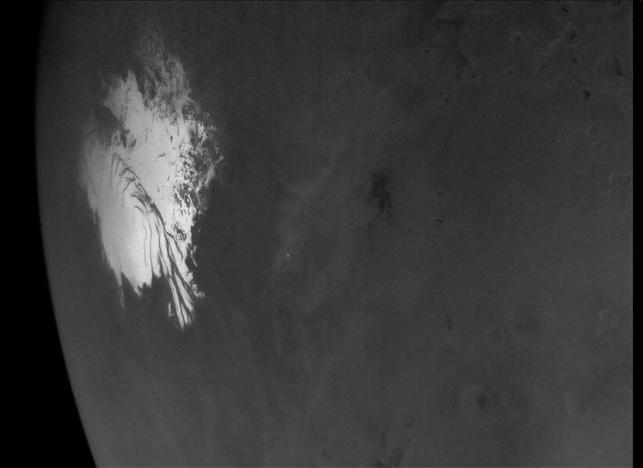
- Capture at T+0: The highest-resolution frame (described in this tutorial) was taken at 1:53 p.m. PDT, at a slant range of approximately 1,000 km from the cap. This results in a pixel scale of 0.7 miles per pixel (1.14 km/pixel).
- Post-capture: The remaining two images were taken at slightly different angles to allow stereo reconstruction if needed.
The raw image was stored in the spacecraft's non-volatile memory and later downlinked to Earth over several days via the Deep Space Network.
4. Data Processing and Calibration
After downlink, the raw data were processed by the Psyche Science Team at Arizona State University:
- Dark current subtraction: A previously measured dark frame was subtracted to remove thermal noise.
- Flat-field correction: Pixel-to-pixel sensitivity variations were corrected using pre-flight flat-field frames.
- Geometric correction: Since the spacecraft was moving, the image was warped to correct for motion blur and then reprojected to a Mars-based coordinate system (MOLA reference).
- Enhancement: A simple contrast stretch was applied to highlight the subtle tonal variations in the ice cap.
The final product (PIA26773) has a dynamic range of 16 bits per pixel, but is typically displayed as an 8-bit PNG for public release.

5. Interpreting the Image
The resulting image reveals the water-ice-rich south polar cap of Mars. Key details:
- Extent: The visible cap spans over 430 miles (700 km) across.
- Composition: The bright white material is primarily water ice, with some carbon dioxide ice mixed in – though during the southern summer (when the image was taken), most CO₂ has sublimated away.
- Surface features: Numerous small pits and fractures are resolved, indicating seasonal sublimation and possible subsurface ice interactions.
- Resolution context: At 1.14 km/pixel, this is sharper than any previous flyby image of the same region, but still coarse compared to Mars-orbiting missions like MRO (which can resolve ~30 cm/pixel). The value lies in the unique spectral data from Psyche's imager and the opportunity to cross-calibrate with other instruments.
Common Mistakes
When analyzing or reproducing similar flyby imaging, avoid these pitfalls:
- Confusing resolution with image quality: High pixel resolution doesn't guarantee good science if the signal-to-noise ratio is low. Psyche's imager had to balance exposure time with motion blur.
- Ignoring geometry: The pixel scale of 0.7 miles per pixel is only correct at the point of closest approach for that specific image. Distances to other parts of the cap varied, affecting local resolution.
- Assuming the cap is static: The south polar cap changes significantly with season. This image captured mid-summer conditions; comparisons to earlier seasons must account for sublimation cycles.
- Overinterpreting gravity assist images: Flyby images are often taken under time constraints and with non-optimal lighting. Don't use them as substitutes for dedicated orbital surveys.
Summary
The Psyche mission's high-resolution view of Mars' south polar cap is a remarkable example of opportunistic science during a gravity assist. By carefully planning the flyby trajectory, preparing the Imager A instrument, acquiring the image at precisely the right moment, and processing the data to correct for various artifacts, the team obtained the sharpest look at the water-ice-rich cap from a flyby. This image not only enhances our understanding of Mars' polar processes but also serves as a calibration target for the mission's future observations of asteroid Psyche. As the spacecraft continues its journey, it demonstrates how interplanetary missions can extract valuable science even during transit.